


; by Rock Hermon Hackshaw.")


Trevor M. Millett
Saba is a tiny island of only five (yes, five) square miles (or 13 sq. km) with a population of about 1,991 residents. Geographically, it is clustered with the Leeward group of Caribbean islands. But it is neither the size of the island nor the size of its population that makes it strange. Though they are not to be overlooked in terms of the peculiarities of Saba. There are many other more interesting features that distinguish Saba.
First of all, the birth of Saba qualifies for attention. Mount Scenery’s reproductive powers as a volcano must be credited with both the maternity and paternity for Saba, which is, but the cone of that long extinct volcano rising abruptly out of the sea. Some dispute the claim that the volcano is completely dormant and argue that it is potentially active.
After being sighted by Christopher Columbus in 1493, the island fell under the authority of the Dutch, the French, the Spanish and the English at various points in its colorful history. But it is the Dutch who settled the island.
Notwithstanding Dutch settlement, English is widely spoken in the island’s four villages—Hell’s Gate, Windwardside, St. John and Bottom, the capital. Even though English is the medium of communication in its schools, Dutch is the official language of what is the smallest municipality of the Caribbean Netherlands.
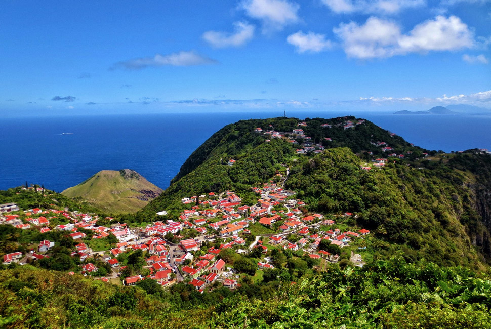 Being a Caribbean island, one would be forgiven for thinking that it is a tropical paradise with beautiful beaches. But you would be absolutely wrong in stereotyping Saba in that way for it is a beachless island, though it boasts of a strong tourism sector.
The absence of beaches betrays its identity as merely the cone of a volcano. The island is therefore ringed by steep cliffs that fall straight down into the sea. Because of its peculiar formation, Saba could not be overrun in the old days of piracy and colonialism. But this also made landing by boat an extremely difficult, daunting task.
No beaches meant no docks. Only the natives, completely familiar with its terrain, could provide the solution. They were able to assist the longboats is use then to easily accomplish that feat. That was the time in Saba’s history when almost all of its male inhabitants were sailors and famous boat-builders.
In those early years, the boats would be built on the high lands and lowered over the cliffs when they were to be launched.
At that time, not only was it difficult for boats to land at Saba but also it was equally difficult for people to move from lower to higher. Early Dutch settlers established the capital or main village, Bottom, 277 meters (or 900 feet) up in the crater. To get to that level, they cut out of the rocks a spectacular staircase of 530 steps that they called The Ladder, thus making it possible for them to move back and forth, up and down, with relative ease.
This man-made staircase is perhaps one of the most interesting features of Saba, which is often described as a fairy tale island with half of its inhabitants fair-haired and white, and the other half of African extraction.
Today Saba boasts of a single main road that was initially thought impossible of construction by experienced civil engineers. It took a naïve amateur engineer (who had been enlightened by nothing more than a correspondence course in engineering) to prove them utterly wrong. Begun in 1938, the road was completed in 1958. Considerable skill is required by drivers to negotiate the sharply curving road.
The island can also be accessed by air in these modern times. There is airline connection with the nearby islands of Sint Maarten and Sint Eustatius. Small aircraft swoop in over the rim of Saba’s crater to land on its 400-meter (1,300 foot) airstrip. Helicopters are also used to get onto and off the island.


 and then